
Data from NASA's
Polar spacecraft, circa 1998, provided crucial
clues to finding magnetic X-points.
Image Credit: NASA


Starfire Tor is the
discoverer and chief researcher of Time Shifts, The Core
Matrix, and Co-Existing Time Lines. These are terms
she coined to describe astounding interconnected phenomenon
in which our reality and dominant current time line is
constantly being edited and restructured.
To learn more about this
ground breaking work please listen to Starfire Tor's many
interviews, including the ones with Whitley Strieber on
Dreamland and her many appearances on Coast to Coast AM with
Art Bell, George Noory and Whitley Strieber.
![]()
The Time Shift Alerts presented by Starfire Tor do not represent all Time Shifts or Time Shift Alerts. Nor does this Time Shift information present all Time Shift science or scientific results. The purpose of sharing this sampling is to educate people about the science of Time Shifts. Part of this Time Shift Alert education involves historical events including the September 11, 2001 attacks in the U.S., the December 26, 2004 earthquake and tsunami in the Sumatra-Indonesia region, and the March 11, 2011 earthquake and tsunami in Japan.
![]()
DATE SPECIFIC DATA
| September 2, 2013 Time Shift Alert
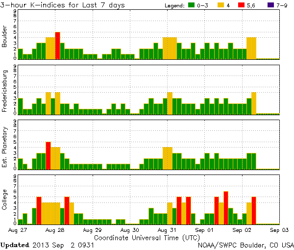
Update: Time Shift Living Dead Time Shift Memory Markers Since August 30, 2013 Earth has been experiencing geomagnetic storming and unsettled magnetic field fluctuations. As you can see by this Latest k-index chart from NOAA, Earth is in the uptick of fluctuating magnetic energy. The latest is from an expected solar wind and CME combo. This solar sourced geomagnetic storming has triggered extended Time Shift and time line edit activity. Besides the Time Shift triggered Alaska earthquake, that I already reported about in an earlier post, episodes of precognition, paranormal incidents, and the Time Shift Living Dead have also appeared globally. Some of the recognizable Time Shift memory markers have been multiple reported incidents of Time Shift Living Dead people. Some of these TSLD are the well known interviewer David Frost, and the award winning actress Julie Harris. And if you are keeping track of multiple TSLD person Nelson Mandela, who I first announced as a multiple Time Shift Living Dead person many years ago, he has left the hospital and gone home. This does not mean that he has regained good health and is taking meetings, but it means that he has once again returned from having recently died. If you are one of those people who recall his having died in the past, including not too long ago - again, then you now know why your brain is retaining conflicting memories from more than one co-existing time line. You are experiencing a glitch in The Core Matrix co-existing time line assimilation program. This program is supposed to make your brain shelve and forget all other co-existing time line experiences, and only utilize the structured memory from the latest co-existing time line ... which I call the dominant time line. The dominant time line is determined by what the conscious brain is focused on. Another Time Shift means at least one new dominant time line. |
| September
3, 2013 Time Shift Alert Update: 6.5 magnitude Time Shift triggered earthquake near Adak Alaska As I have taught many times, including as part of my Time Shift Alerts, some earthquakes are triggered by Time Shift activity. I write in part: "Due to frequency and time line edit changes associated with Time Shifts there may be Time Shift triggered earthquake, volcano, tornado, weather, and geophysical events." Many of Alaska's large earthquakes have been triggered by Time Shift activity, just as the August 30, 2013 7.0 magnitude Alaska earthquake was. This has more to do with that areas geophysical properties than anything else. The area is earthquake prone. Todays Alaska earthquake appears not to have set off a tsunami, which is fortunate. An earlier Time Shift triggered Alaska earthquake triggered an historical tsunami. On July 9, 1958 the highest tsunami ever recorded - at 1,720 ft - was set off by an 8.3 earthquake near Lituya Bay. The earthquake loosened over 40 million cubic yards of rock above the bay shore, and when that rock fell into the bay it caused the historic tsunami. How is this related to Time Shifts? On July 7, 1958 there were powerful solar flares on the Sun. The energy of those flares resulted in, among other things, geomagnetic storming beginning just 31 hours after the flares. There were also radio blackouts caused by the conditions. In fact, 1958 was a banner year for powerful Time Shift and time line edit activity. |
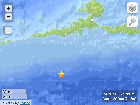
| M6.5 - 77km SSW of Atka, Alaska 2013-09-04 02:32:33 UTC Summary Location and Magnitude contributed by: USGS, NEIC, Golden, Colorado (and predecessors) Event Time
Location51.592°N 174.760°W depth=39.9km (24.8mi) Nearby Cities
Tectonic Summary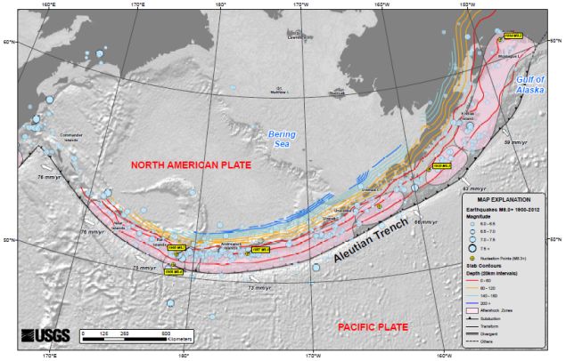
Seismotectonics of AlaskaThe Aleutian arc extends approximately 3,000 km from the Gulf of Alaska in the east to the Kamchatka Peninsula in the west. It marks the region where the Pacific plate subducts into the mantle beneath the North America plate. This subduction is responsible for the generation of the Aleutian Islands and the deep offshore Aleutian Trench. The curvature of the arc results in a westward transition of relative plate motion from trench-normal (i.e., compressional) in the east to trench-parallel (i.e., translational) in the west, accompanied by westward variations in seismic activity, volcanism, and overriding plate composition. The Aleutian arc is generally divided into three regions: the western, central, and eastern Aleutians. Relative to a fixed North America plate, the Pacific plate is moving northwest at a rate that increases from roughly 60 mm/yr at the arc's eastern edge to 76 mm/yr near its western terminus. The eastern Aleutian arc extends from the Alaskan Peninsula in the east to the Fox Islands in the west. Motion along this section of the arc is characterized by arc-perpendicular convergence and Pacific plate subduction beneath thick continental lithosphere. This region exhibits intense volcanic activity and has a history of megathrust earthquakes. The central Aleutian arc extends from the Andreanof Islands in the east to the Rat Islands in the west. Here, motion is characterized by westward-increasing oblique convergence and Pacific plate subduction beneath thin oceanic lithosphere. Along this portion of the arc, the Wadati-Benioff zone is well defined to depths of approximately 200 km. Despite the obliquity of convergence, active volcanism and megathrust earthquakes are also present along this margin. The western Aleutians, stretching from the western end of the Rat Islands in the east to the Commander Islands, Russia, in the west, is tectonically different from the central and eastern portions of the arc. The increasing component of transform motion between the Pacific and North America plates is evidenced by diminishing active volcanism; the last active volcano is located on Buldir Island, in the far western portion of the Rat Island chain. Additionally, this portion of the subduction zone has not hosted large earthquakes or megathrust events in recorded history. Instead, the largest earthquakes in this region are generally shallow, predominantly strike-slip events with magnitudes between M5-6. Deeper earthquakes do occur, albeit rather scarcely and with small magnitudes (M<4), down to approximately 50 km. Most of the seismicity along the Aleutian arc results from thrust faulting that occurs along the interface between the Pacific and North America plates, extending from near the base of the trench to depths of 40 to 60 km. Slip along this interface is responsible for generating devastating earthquakes. Deformation also occurs within the subducting slab in the form of intermediate-depth earthquakes that can reach depths of 250 km. Normal faulting events occur in the outer rise region of the Aleutian arc resulting from the bending of the oceanic Pacific plate as it enters the Aleutian trench. Additionally, deformation of the overriding North America plate generates shallow crustal earthquakes. The Aleutian arc is a seismically active region, evidenced by the many moderate to large earthquakes occurring each year. Since 1900, this region has hosted twelve large earthquakes (M>7.5) including the May 7, 1986 M8.0 Andreanof Islands, the June 10, 1996 M7.9 Andreanof Islands, and the November 17, 2003 M7.8 Rat Islands earthquakes. Six of these great earthquakes (M8.3 or larger) have occurred along the Aleutian arc that together have ruptured almost the entire shallow megathrust contact. The first of these major earthquakes occurred on August 17, 1906 near the island of Amchitka (M8.3) in the western Aleutian arc. However, unlike the other megathrust earthquakes along the arc, this event is thought to have been an intraplate event occurring in the shallow slab beneath the subduction zone interface. The first megathrust event along the arc during the 20th century was the November 10, 1938 M8.6 Shumagin Island earthquake. This event ruptured an approximately 300 km long stretch of the arc from the southern end of Kodiak Island to the northern end of the Shumagin Islands and generated a small tsunami that was recorded as far south as Hawaii. The April 1, 1946 M8.6 Unimak Island earthquake, located in the central Aleutian arc, was characterized by slow rupture followed by a devastating Pacific-wide tsunami that was observed as far south as the shores of Antarctica. Although damage from earthquake shaking was not severe locally, tsunami run-up heights were recorded as high as 42 m on Unimak Island and tsunami waves in Hilo, Hawaii also resulted in casualties. The slow rupture of this event has made it difficult to constrain the focal mechanism and depth of the earthquake, though it is thought to have been an interplate thrust earthquake. The next megathrust earthquake occurred along the central portion of the Aleutian arc near the Andreanof Islands on March 9, 1957, with a magnitude of M8.6. The rupture length of this event was approximately 1200 km, making it the longest observed aftershock zone of all the historic Aleutian arc events. Although only limited seismic data from this event are still available, significant damage and tsunamis were observed on the islands of Adak and Unimak with tsunami heights of approximately 13 m. The easternmost megathrust earthquake was the March 28, 1964 M9.2 Prince William Sound earthquake, currently the second largest recorded earthquake in the world. The event had a rupture length of roughly 700 km extending from Prince William Sound in the northeast to the southern end of Kodiak Island in the southwest. Extensive damage was recorded in Kenai, Moose Pass, and Kodiak but significant shaking was felt over a large region of Alaska, parts of western Yukon Territory, and British Columbia, Canada. Property damage was the largest in Anchorage, as a result of both the main shock shaking and the ensuing landslides. This megathrust earthquake also triggered a devastating tsunami that caused damage along the Gulf of Alaska, the West Coast of the United States, and in Hawaii. The westernmost Aleutians megathrust earthquake followed a year later on February 4, 1965. This M8.7 Rat Islands earthquake was characterized by roughly 600 km of rupture. Although this event is quite large, damage was low owing to the region's remote and sparsely inhabited location. A relatively small tsunami was recorded throughout the Pacific Ocean with run-up heights up to 10.7 m on Shemya Island and flooding on Amchitka Island. Although the Aleutian arc is highly active,
seismicity is rather discontinuous, with two regions
that have not experienced a large (M>8.0)
earthquake in the past century: the Commander
Islands in the western Aleutians and the Shumagin
Islands in the east. Due to the dominantly transform
motion along the western arc, there is potential
that the Commander Islands will rupture in a
moderate to large strike-slip earthquake in the
future. The Shumagin Islands region may also have
high potential for hosting a large rupture in the
future, though it has been suggested that little
strain is being accumulated along this section of
the subduction zone, and thus associated hazards may
be reduced. East of the Aleutian arc along the Gulf of Alaska,
crustal earthquakes occur as a result transmitted
deformation and stress associated with the
northwestward convergence of the Pacific plate that
collides a block of oceanic and continental material
into the North America plate. In 2002, the Denali
Fault ruptured in a sequence of earthquakes that
commenced with the October 23 M6.7 Nenana Mountain
right-lateral strike-slip earthquake and culminated
with the November 3, M7.9 Denali earthquake which
started as a thrust earthquake along a then
unrecognized fault and continued with a larger
right-lateral strike-slip event along the Denali and
Totschunda Faults. |
| September
4, 2013 Time Shift Alert Update: 6.5 magnitude Time Shift triggered earthquake near Japan As I have taught many times, including as part of my Time Shift Alerts, some earthquakes are triggered by Time Shift activity. I write in part: "Due to frequency and time line edit changes associated with Time Shifts there may be Time Shift triggered earthquake, volcano, tornado, weather, and geophysical events." This 6.5 magnitude earthquake, near the Izu islands, Japan came only 2 hours apart from the Alaska 6.5 earthquake that I reported on earlier. You are not seeing double. They are twin earthquakes. They are twin Time Shift triggered earthquakes. Many of the large earthquakes, from this region of the planet, have been triggered by Time Shift activity, just as the August 30, 2013 7.0 magnitude Alaska earthquake was and September 3, 2013 6.5 magnitude Alaska earthquake was. This has more to do with that areas geophysical properties than anything else. The area is earthquake prone. |
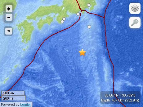
| M6.5
- Izu Islands, Japan region 2013-09-04 00:18:24 UTC SummaryLocation and Magnitude
contributed by: USGS, NEIC, Golden, Colorado (and
predecessors)
Event Time
Location30.007°N 138.789°E depth=407.0km (252.9mi) Nearby Cities
Tectonic Summary Seismotectonics of the Philippine Sea and VicinityThe Philippine Sea plate is bordered by the larger Pacific and Eurasia plates and the smaller Sunda plate. The Philippine Sea plate is unusual in that its borders are nearly all zones of plate convergence. The Pacific plate is subducted into the mantle, south of Japan, beneath the Izu-Bonin and Mariana island arcs, which extend more than 3,000 km along the eastern margin of the Philippine Sea plate. This subduction zone is characterized by rapid plate convergence and high-level seismicity extending to depths of over 600 km. In spite of this extensive zone of plate convergence, the plate interface has been associated with few great (M>8.0) ‘megathrust’ earthquakes. This low seismic energy release is thought to result from weak coupling along the plate interface (Scholz and Campos, 1995). These convergent plate margins are also associated with unusual zones of back-arc extension (along with resulting seismic activity) that decouple the volcanic island arcs from the remainder of the Philippine Sea Plate (Karig et al., 1978; Klaus et al., 1992). South of the Mariana arc, the Pacific plate is subducted beneath the Yap Islands along the Yap trench. The long zone of Pacific plate subduction at the eastern margin of the Philippine Sea Plate is responsible for the generation of the deep Izu-Bonin, Mariana, and Yap trenches as well as parallel chains of islands and volcanoes, typical of circum-pacific island arcs. Similarly, the northwestern margin of the Philippine Sea plate is subducting beneath the Eurasia plate along a convergent zone, extending from southern Honshu to the northeastern coast of Taiwan, manifested by the Ryukyu Islands and the Nansei-Shoto (Ryukyu) trench. The Ryukyu Subduction Zone is associated with a similar zone of back-arc extension, the Okinawa Trough. At Taiwan, the plate boundary is characterized by a zone of arc-continent collision, whereby the northern end of the Luzon island arc is colliding with the buoyant crust of the Eurasia continental margin offshore China. Along its western margin, the Philippine Sea plate is associated with a zone of oblique convergence with the Sunda Plate. This highly active convergent plate boundary extends along both sides the Philippine Islands, from Luzon in the north to the Celebes Islands in the south. The tectonic setting of the Philippines is unusual in several respects: it is characterized by opposite-facing subduction systems on its east and west sides; the archipelago is cut by a major transform fault, the Philippine Fault; and the arc complex itself is marked by active volcanism, faulting, and high seismic activity. Subduction of the Philippine Sea Plate occurs at the eastern margin of the archipelago along the Philippine Trench and its northern extension, the East Luzon Trough. The East Luzon Trough is thought to be an unusual example of a subduction zone in the process of formation, as the Philippine Trench system gradually extends northward (Hamburger et al., 1983). On the west side of Luzon, the Sunda Plate subducts eastward along a series of trenches, including the Manila Trench in the north, the smaller less well-developed Negros Trench in the central Philippines, and the Sulu and Cotabato trenches in the south (Cardwell et al., 1980). At its northern and southern terminations, subduction at the Manila Trench is interrupted by arc-continent collision, between the northern Philippine arc and the Eurasian continental margin at Taiwan and between the Sulu-Borneo Block and Luzon at the island of Mindoro. The Philippine fault, which extends over 1,200 km within the Philippine arc, is seismically active. The fault has been associated with major historical earthquakes, including the destructive M7.6 Luzon earthquake of 1990 (Yoshida and Abe, 1992). A number of other active intra-arc fault systems are associated with high seismic activity, including the Cotabato Fault and the Verde Passage-Sibuyan Sea Fault (Galgana et al., 2007). Relative plate motion vectors near the Philippines (about 80 mm/yr) is oblique to the plate boundary along the two plate margins of central Luzon, where it is partitioned into orthogonal plate convergence along the trenches and nearly pure translational motion along the Philippine Fault (Barrier et al., 1991). Profiles B and C reveal evidence of opposing inclined seismic zones at intermediate depths (roughly 70-300 km) and complex tectonics at the surface along the Philippine Fault. Several relevant tectonic elements, plate boundaries and active volcanoes, provide a context for the seismicity presented on the main map. The plate boundaries are most accurate along the axis of the trenches and more diffuse or speculative in the South China Sea and Lesser Sunda Islands. The active volcanic arcs (Siebert and Simkin, 2002) follow the Izu, Volcano, Mariana, and Ryukyu island chains and the main Philippine islands parallel to the Manila, Negros, Cotabato, and Philippine trenches. Seismic activity along the boundaries of the Philippine Sea Plate (Allen et al., 2009) has produced 7 great (M>8.0) earthquakes and 250 large (M>7) events. Among the most destructive events were the 1923 Kanto, the 1948 Fukui and the 1995 Kobe (Japan) earthquakes (99,000, 5,100, and 6,400 casualties, respectively), the 1935 and the 1999 Chi-Chi (Taiwan) earthquakes (3,300 and 2,500 casualties, respectively), and the 1976 M7.6 Moro Gulf and 1990 M7.6 Luzon (Philippines) earthquakes (7,100 and 2,400 casualties, respectively). There have also been a number of tsunami-generating events in the region, including the Moro Gulf earthquake, whose tsunami resulted in more than 5000 deaths. |

| September
4, 2013: This ethereal looking green, purple, and red hued aurora was dancing and glowing in the skies over Iceland on September 3, 2013. This awesome photo was taken by Stian Rekda. What does this aurora remind you of? Although auroras do not cause Time Shifts, they are sometimes created by the same solar energy that triggers geomagnetic storms. This is why some auroras act as markers that Time Shift activity is in progress. This aurora was indeed a Time Shift marker. |
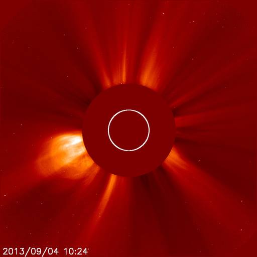
| September
5, 2013 Solar Activity Update: Possible Time Shift Alert On September 4, 2013 the Sun erupted with 7 C class solar flares and 1 prominence. 6 of the solar flares erupted from sunspot 1837, which is still Earth facing but slightly off center as it continues its rotation to the Sun's outer limb. This SOHO photo shows one of the more powerful C class solar flares from yesterday, which then became a coronal mass ejection [CME] as it continued out into space. It is possible that part of the energy from this CME may hit Earth, although I cannot say for sure at this time. We are still waiting for the next solar wind hit, which could happen today or tomorrow if its course has not been changed. If this solar wind hit happens, as expected, then this solar wind may trigger geomagnetic storming in parts of the world. If this geomagnetic storming manifests, then this is what can trigger Time Shift and time line edit activity. Stay tuned. |
|
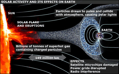
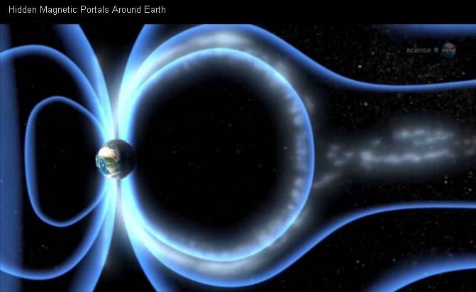
September 6, 2013 NASA Discovers Hidden Magnetic Portals That Link The Sun And Earth This is part of the Sun Earth Time Shift mechanism In 2012 NASA announced that it sponsored research that discovered hidden portals that link the magnetic field on the Sun to the magnetic field on Earth. These portals or gateways have been named "X-points" or "electron diffusion regions". These portals create an uninterrupted 93 million miles path between the Sun and the Earth. NASA also discovered that these magnetic portals are not always open, and may only be open dozens of times a day. This means that the uninterrupted magnetic path can only be effective when the portal is open, and when the right kind of solar energy hits the portal when it is open. When an open magnetic portal meets up with a solar wind, or coronal mass ejection [CME], this connection triggers the type of geomagnetic storming that can trigger Time Shift and time line edit activity. For years I have been teaching about this entangled Sun-Earth energy connection, in relationship to both geomagnetic storms and Time Shifts. Wormholes - including those from frame-dragging around the Earth - are also involved. Some of these wormholes quite small and others are larger. The elements of frame-dragging, fueled by an uninterrupted stream of solar energy, plays a large role in creating Time Shift and time line edit activity. Frame-dragging happens when a rotating body, like a planet or other cosmic body, distorts the space-time continuum just beyond the rotating body. Inner regions can at times drag at different speeds than outer regions, and likewise affect light as it travels in and around the frame-dragging space. I am saying things at rather a simple level, but the end product is that time works differently at different levels of the frame-dragging. This is not all that there is to how Time Shifts are triggered, but this will at least give you a tantalizing look at the science involved beyond just a Sun-Earth geomagnetic storm connection. |
|
Hidden Portals in Earth's
Magnetic Field
July 2,
2012
A NASA-sponsored
researcher at the University of Iowa has developed a
way for spacecraft to hunt down hidden magnetic
portals in the vicinity of Earth. These gateways
link the magnetic field of our planet to that of the
sun, setting the stage for stormy space weather.
Image Credit: Science@NASA
A favorite theme of science fiction is "the portal"--an extraordinary opening in space or time that connects travelers to distant realms. A good portal is a shortcut, a guide, a door into the unknown. If only they actually existed.... It turns out that they do, sort of, and a NASA-funded researcher at the University of Iowa has figured out how to find them. "We call them X-points or electron diffusion regions," explains plasma physicist Jack Scudder of the University of Iowa. "They're places where the magnetic field of Earth connects to the magnetic field of the Sun, creating an uninterrupted path leading from our own planet to the sun's atmosphere 93 million miles away." Observations by NASA's THEMIS spacecraft and Europe's Cluster probes suggest that these magnetic portals open and close dozens of times each day. They're typically located a few tens of thousands of kilometers from Earth where the geomagnetic field meets the onrushing solar wind. Most portals are small and short-lived; others are yawning, vast, and sustained. Tons of energetic particles can flow through the openings, heating Earth's upper atmosphere, sparking geomagnetic storms, and igniting bright polar auroras. NASA is planning a mission called "MMS," short for Magnetospheric Multiscale Mission, due to launch in 2014, to study the phenomenon. Bristling with energetic particle detectors and magnetic sensors, the four spacecraft of MMS will spread out in Earth's magnetosphere and surround the portals to observe how they work. Just one problem: Finding them. Magnetic portals are invisible, unstable, and elusive. They open and close without warning "and there are no signposts to guide us in," notes Scudder. Actually, there are signposts, and Scudder has found them. Portals form via the process of magnetic reconnection. Mingling lines of magnetic force from the sun and Earth criss-cross and join to create the openings. "X-points" are where the criss-cross takes place. The sudden joining of magnetic fields can propel jets of charged particles from the X-point, creating an "electron diffusion region." To learn how to pinpoint these events, Scudder looked at data from a space probe that orbited Earth more than 10 years ago. "In the late 1990s, NASA's Polar spacecraft spent years in Earth's magnetosphere," explains Scudder, "and it encountered many X-points during its mission." Data from NASA's
Polar spacecraft, circa 1998, provided crucial
clues to finding magnetic X-points.
Image Credit: NASA
Because Polar carried sensors similar to those of MMS, Scudder decided to see how an X-point looked to Polar. "Using Polar data, we have found five simple combinations of magnetic field and energetic particle measurements that tell us when we've come across an X-point or an electron diffusion region. A single spacecraft, properly instrumented, can make these measurements." This means that single member of the MMS constellation
using the diagnostics can find a portal and alert other
members of the constellation. Mission planners long
thought that MMS might have to spend a year or so
learning to find portals before it could study them.
Scudder's work short cuts the process, allowing MMS to
get to work without delay. It's a shortcut worthy of the best portals of fiction,
only this time the portals are real. And with the new
"signposts" we know how to find them. Related Links
|
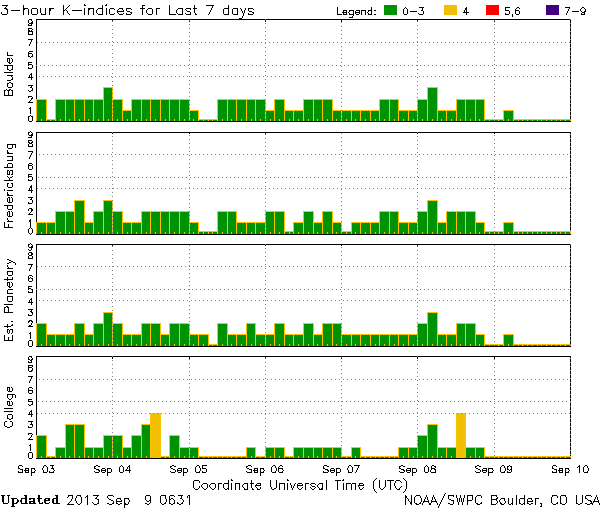
| September
9, 2013 Time Shift and Solar Activity Update: All of the solar energy that was expected to hit Earth, starting on September 5 or 6, 2013, never arrived. The solar energy is lost in space. This includes a solar wind and a possible CME [coronal mass ejection] hit. Where the solar energy went is unknown. As I've pointed out in recent similar cases, sometimes missing energy IS the evidence that Time Shift and time line edits are in progress. The last documented Time Shift activity I have are the triple 6.5 magnitude earthquakes September 1, 2013, September 3, 2013, and September 4, 2013. As you can see in this current NOAA K-Index chart, Earth's magnetic field levels have been low with no geomagnetic activity since September 5, 2013. There is a tad of unsettled conditions, seen in 2 mild yellow spikes, but these conditions have no corresponding data that identifies the source of the yellow spikes as being any of the expected solar energy hits. The previous Time Shift activity, associated with the earthquakes, could have continued beyond the last Time Shift earthquake - because that can and does happen - but without other Time Shift marker evidence, what exactly happened to the solar energy is a big question mark. Currently, there is only 1 Earth facing sunspot, which is 1838. A moderate sized coronal holes has released a solar wind, which may reach Earth sometime between September 13-15, 2013. The last solar flare - a C class that was not Earth facing - erupted on September 6, 2013. Solar action will pick up. 2013 is solar maximum after all. Stay tuned. |
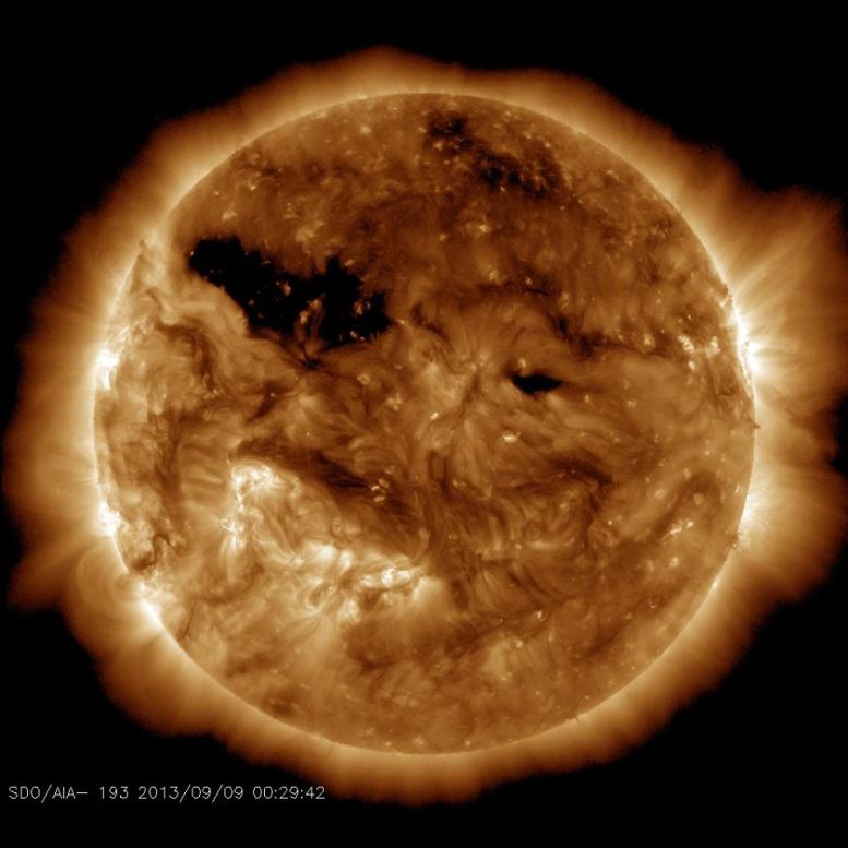
| September
9, 2013 Time Shift and Solar Activity Update
2: This is the Sun as it looks now, in this photo from SDO. The moderately sized coronal hole, that I mentioned in my earlier update and that can be seen in the upper left quadrant, is the one from which a solar wind is flowing toward Earth. If nothing interferes with the solar wind's path, it will reach Earth sometime between September 13-15, 2013. If the coronal hole grows in size as it becomes centered toward Earth, then the solar wind itself will be amplified. Based on sheer volume, the larger the coronal hole the stronger and more global the solar wind will be. The stronger and more global the solar wind, the higher the chance that it will trigger geomagnetic storming. Consequently, geomagnetic storming can trigger Time Shifts and time line edit activity. Beyond this, the Sun is eerily quiet. Stay tuned. |
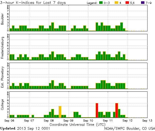
| September
12, 2013 Time Shift Update A Geomagnetic Storm Mystery Take a look at this NOAA K-Index chart. Note that on September 11 and 12, 2013 there is geomagnetic activity in parts of the world. Those are the 2 red lines, which denote a K-5 geomagnetic storm. The storm condition lasts for only a brief time, goes back down into the green and then back up again into the red the next day. What makes this a mystery, is that there has been zero solar activity with which to trigger those red lines. Nothing. As I already reported, there were no Earth facing coronal mass ejections [CME] as of late, and the next expected solar wind isn't due until September 13, 2013 at the earliest. There have been no reports of Earth's magnetic field tipping, on the dates that the red lines appeared, which can create geomagnetic conditions. But there have been auroras, during the times of the red lines, which shows a physical confirmation that the red lines are not false readings. What does this mean? At the very least, because geomagnetic storm conditions can trigger Time Shifts, that at those red line times there may have been Time Shift and time line edit activity - even though no physical cause of the geomagnetic conditions can be tracked. In fact, the scientific community is abuzz at how quiet the Sun has been recently in this time of solar maximum. The fact that there has been a double geomagnetic storm event - with no clear cause - is worthy of the best Time Shift mysteries. In fact, I've demonstrated many times how the lack of solar physical evidence can in itself be Time Shift evidence. This is usually under conditions when the Sun has erupted with an Earth facing CME, or has spewed an Earth facing solar wind from a coronal hole, and then the CME and/or solar wind vanishes before hitting Earth. And yet Time Shift markers are reported, just as they would happen if the solar energy had hit Earth and triggered Time Shift activity. But in this current mystery things are backwards. Earth has experienced geomagnetic hits when there is no physical evidence of solar activity having caused it. |
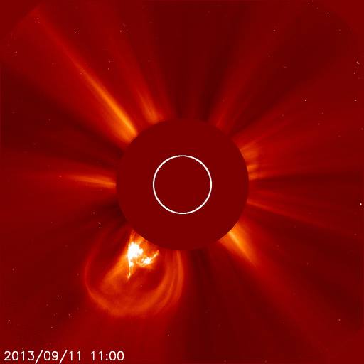
| September
12, 2013 Solar Activity Update: The Sun has finally awakened with the eruption of a magnetic filament on September 11, 2013, which caused a bright coronal mass ejection [CME]. You can see it in this SOHO photo. The CME was not Earth directed, so it is not expected to be geo-effective in our part of the solar system. Also, there are now 4 sunspots on the Earth facing side of the Sun, although none of them are as yet powerful enough to erupt. At one point, only a few days ago, there was only 1 visible and very weak sunspot. The Sun is in solar maximum, but you would not know it by the current state of things on the Sun. |
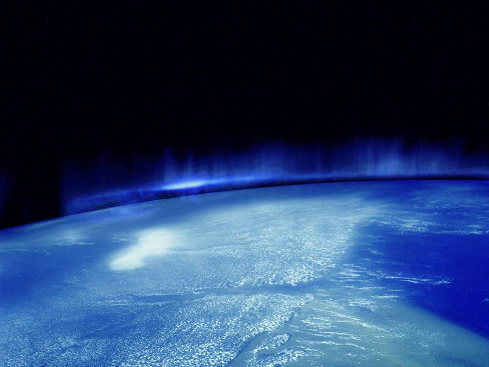
| September
13, 2013 This panoramic view of an aurora was taken from the International Space Station. The aurora can be seen arcing across Earth's horizon. Deep space can been seen beyond the Earth. A special filter was used, which brings out a blue color not usually seen in auroras with the naked eye. But with this filter in place, which subdues the more dominant red, green, and purple frequencies - the blue color becomes dominant and glows beautifully. Enjoy, and be sure to click on the photo to see the whole photo. |
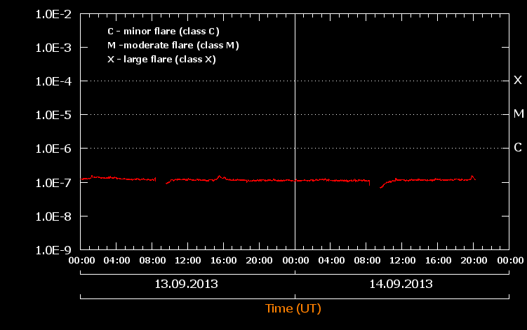
| September
14, 2013 Solar Activity and Time Shift Update: Take a look at this solar flare chart, which is designed to graph the intensity of solar flares when they happen. Take a look at the horizontal red line at the 1.OE-7 level. This is what is called solar flat-lining, and this is the odd solar condition that I've been reporting about. Our Sun is in solar maximum, and yet the behavior is anything but maximum. Even though there are currently 3 Earth facing sunspots [1839, 1841, 1842], none of them are powerful and 2 of them [1839, 1842] have almost rotated off of the Earth facing side. The expected solar wind - which was expected to hit starting yesterday or today, has either not arrived full force, has taken a wrong turn somewhere in space and will never arrive, or has vanished all together because that solar wind is not registering as expected. And yet there have been some beautiful auroras, which are markers that a solar wind is hitting Earth's magnetosphere. Some scientists are postulating that this flat lined condition is really a valley between a double peaked solar maximum. This means that the 2013 solar maximum is still in the works, and as soon as this low activity is over the solar maximum will rise to the occasion. It is also important, to keep in mind - as I have already reported, that a complete solar magnetic pole flip is expected around the end of the year. Pole flips are normal for the Sun, especially during solar maximum years, and not something to get worked up about. The big question is how this flat-lined condition, in this solar maximum year, will impact the expected solar pole flip. These are questions that can only be answered through direct observation and experience. Time Shifts always play a role with anything involving the Sun, not because it controls the Sun - it does not - but because of the symbiotic relationship between solar activity and the triggering of Time Shift and time line edit activity. I have written many reports that talk about the absence of physical solar energy Earth hits and the presence of Time Shift markers during that same time. In other words, I've demonstrated how a Time Shift can be in progress even when the solar Time Shift trigger is physically missing in the current co-existing time line. Of course, that solar energy had to trigger the Time Shift in some co-existing time line for us to experience those Time Shift markers - such as the recent auroras. This means that the Time Shift itself, for whatever reason, edited out the solar evidence. This is how and why some Earth directed solar energy seemingly vanishes. The event becomes a dual co-existing time line physical and memory conflict. |
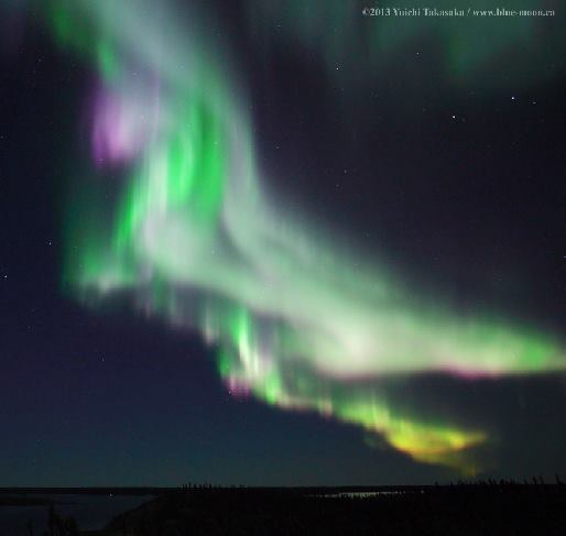
| Unicorn
Winged Horse Aurora Flies Over Prelude Lake,
Yellowknife, Northwest Territories, Canada When I saw this unique aurora photograph it looked to me like a Pegasus winged horse, with unicorn, in flight. Because a winged horse has always been my logo [check out my website] I of course wanted to share this aurora image with you. Photo by Yuichi Takasaka. |
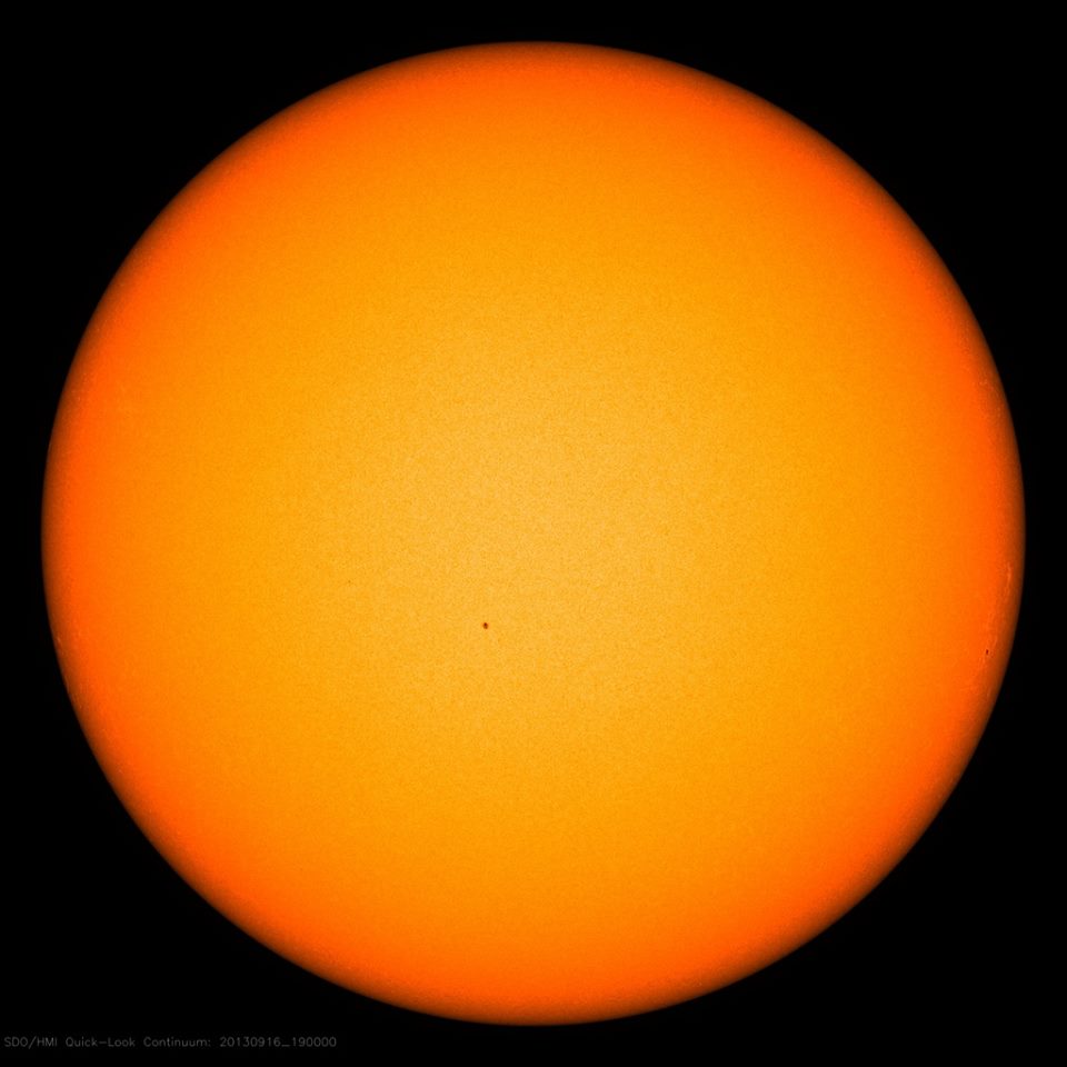
| September
16, 2013 Solar Activity and Time Shift Update: The Sun is still flat lining, when it comes to Earth facing solar activity. Click on this current SDO photo of the Sun, and you'll see only one small red dot there. That is small sunspot 1841, and it is not actively erupting. It is just there, all alone with no other sunspots to keep it company. The solar wind, that was supposed to have hit Earth as early September 13, 2013, is nowhere to be seen. Someone must be very optimistic, because the date of solar wind arrival has been moved several times. Now the alert has it as arriving September 15-16, 2013. Since today is the 16th, and Earth's magnetic field has not shown a geomagnetic uptick, I wonder if the entire solar wind arrival will be canceled and deemed "lost in space" - again. Some scientists are postulating that this flat lined condition is really a valley between a double peaked solar maximum. This means that the 2013 solar maximum is still in the works, and as soon as this low activity is over the solar maximum will rise to the occasion. It is also important, to keep in mind - as I have already reported, that a complete solar magnetic pole flip is expected around the end of the year. Pole flips are normal for the Sun, especially during solar maximum years, and not something to get worked up about. The big question is how this flat-lined condition, in this solar maximum year, will impact the expected solar pole flip. These are questions that can only be answered through direct observation and experience. Time Shifts always play a role with anything involving the Sun, not because it controls the Sun - it does not - but because of the symbiotic relationship between solar activity and the triggering of Time Shift and time line edit activity. I have written many reports that talk about the absence of physical solar energy Earth hits and the presence of Time Shift markers during that same time. In other words, I've demonstrated how a Time Shift can be in progress even when the solar Time Shift trigger is physically missing in the current co-existing time line. Of course, that solar energy had to trigger the Time Shift in some co-existing time line for us to experience those Time Shift markers - such as the recent auroras. This means that the Time Shift itself, for whatever reason, edited out the solar evidence. This is how and why some Earth directed solar energy seemingly vanishes. The event becomes a dual co-existing time line physical and memory conflict. |
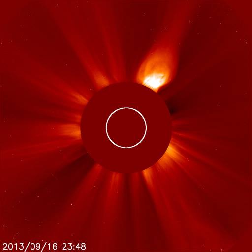
| September
17, 2013 Solar Activity and Time Shift Update: Something unusual has happened and you read it here first Take a look at this SOHO photo from September 16, 2013 at 23:48 UT time. Note the eruption in the 1 o'clock position. I have been watching it develop since around the 14:00 UT hour on the same day. The eruption continued into today September 17, 2013, where it continued out into space as a coronal mass ejection [CME]. I followed the CME on a number of different space cameras, watching its expansion away from the Sun. Just by looking at the size of the eruption, it looks to be a low C class flare. It certainly is very obvious, being that it has been in motion for about 24 hours. Then why am I the only one showing this data? Why hasn't this eruption appeared anywhere in anyone else's data base, which it does not. All solar data bases still show the Sun as flat lining with a single low energy sunspot near center, and 2-3 new sunspots forming on the outer limbs where they are currently quiet. So if the flare I'm showing you is not from a sunspot, then that leaves the source to be a magnetic filament and/or prominence. If that is what this eruption sources from, it should still register as a CME. Yet no solar data base has this listed. I cannot even tell you whether this solar eruption is Earthbound because it does not exist in any of the solar data bases - as yet. This may or may not resolve. If others suddenly start reporting it - a day late - then I'll have to take the time lapse into consideration as a Time Shift time line edit marker. If no data base includes this at any point, then that too will become a Time Shift and time line edit marker. |
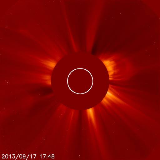
| September
18, 2013 Solar Activity and Time Shift Alert: The Sun has now awakened and has 7 Earth facing sunspots Yesterday September 17, 2013 I posted about a September 16, 2013 CME [coronal mass ejection] that I had been watching develop, and that no one else had reported on. A notation on it wasn't even in any of the solar databases. Nothing has changed in that respect. Then yesterday September 17, 2013 another CME erupted close to the area of the mystery CME. That is what you see in this SOHO photo. Like the CME before it, this one went unremarked upon in solar databases. Then, as if only I was awake at the helm, sunspots began to bloom all over the Earth facing side of the Sun. In fact, where there was only 1 lone sunspot before there are now 7 Earth facing sunspots # 1840, 1841, 1843, 1844, 1845, 1846, 1847. Some of them are in various stages of erupting with Earth facing sunspot 1846 have erupted with a C 3.9 class solar flare and CME. Although the course of these multiple CME is not exactly known as yet, at least one of them may brush by Earth. Since there is also a new coronal hole with a new solar wind flow, which is due to hit Earth possibly September 22, 2013, Earth may be in for more than one Time Shift trigger. Or, as I've reported for the past month, this solar energy may vanish into the Twilight Zone. Whichever happens, what is happening now is a Time Shift Alert. Here are some of the top Time Shift memory markers to watch out for. Be sure to click on the CME photo so that you can see the whole photo. Due to frequency and time line edit changes associated with Time Shifts there may be Time Shift triggered earthquake, volcano, tornado, weather, and geophysical events. Tech communications may be disrupted, cetaceans may strand or swim wrong way. Auroras will form. Time Shifts create an amplification of paranormal activity, ghost activity, haunting activity, poltergeist activity, apports, synchronicity, psi abilities, time/word/object prompts, deja vu, psychic dreaming, precognition events, awareness of Time Shift Living Dead persons, altered time line events, time line looping, altered terrain, altered structures, altered world events and more. |
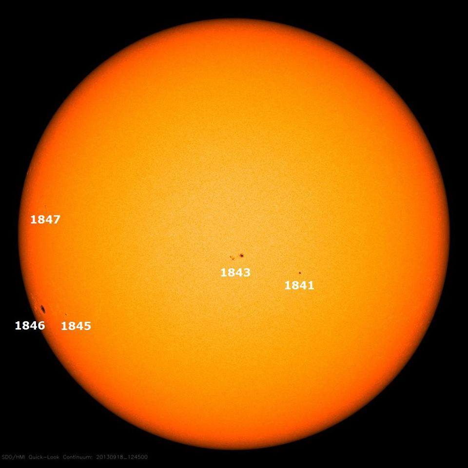
| September
18, 2013 Solar Activity and Time Shift Alert 2: The Sun has now awakened and has 5 Earth facing sunspots Earlier today I posted that the Sun had developed 7 Earth facing sunspots. Since then 2 of the sunspots have rotated onto the far side of the Sun. This leaves 5 Earth facing sunspots, which you can see in this current SDO solar image. The 5 active Earth facing sunspots are now #1841, 1843, 1845, 1846, 1847. Sunspot 1846 is the one that erupted today with a C 3.9 class solar flare and CME. It takes about 2 weeks for a sunspot to rotate from solar limb to solar limb depending on where the sunspot began its life. Read my earlier post for more info about this solar awakening. Time will tell just how awake the Sun will remain, and what impact that will have on the Earth - not to mention Time Shift and time line edit activity. The Sun can protect the Earth from cosmic ray damage because the solar wind creates a heliosphere envelope that acts as a guard. But there are times when the Sun can cause damage, including when it cannot prevent the heliosphere from shrinking inside of Earth's orbit which nullifies the protection. And of course if there is a Carrington type X flare event, the damage on Earth could be challenging in the tech department. Here are some of the top Time Shift memory markers to watch out for. Due to frequency and time line edit changes associated with Time Shifts there may be Time Shift triggered earthquake, volcano, tornado, weather, and geophysical events. Tech communications may be disrupted, cetaceans may strand or swim wrong way. Auroras will form. Time Shifts create an amplification of paranormal activity, ghost activity, haunting activity, poltergeist activity, apports, synchronicity, psi abilities, time/word/object prompts, deja vu, psychic dreaming, precognition events, awareness of Time Shift Living Dead persons, altered time line events, time line looping, altered terrain, altered structures, altered world events and more. |
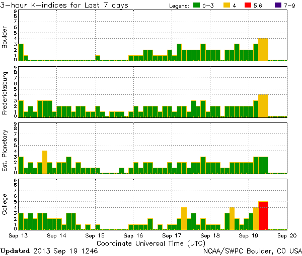
| September
19, 2013 Solar Activity and Time Shift Alert: Geomagnetic and Time Shift conditions in progress A solar wind - which one I cannot say - has reached Earth and is causing geomagnetic storming and unsettled geomagnetic conditions in various parts of the world. I cannot say which solar wind this is because no specific solar wind was expected on this exact date. So this is either one of the long past 'lost in space' solar winds, which I've reported about in previous reports, or this is the solar wind expected to hit on September 22, 2013 - which makes it unnaturally early. Once an Earth directed solar wind leaves a coronal hole, it takes about 4 days to reach Earth. That is roughly a 93 million mile journey. An Earth facing CME [coronal mass ejection], depending on the power behind the eruption, can begin effecting Earth right away with the bulk of the particles hitting Earth in 2-3 days. This geomagnetic storming, along with the unsettled geomagnetic condition, has triggered Time Shift and time line edit activity. This NOAA K-index chart shows the current geomagnetic intensities including the red lines that signify geomagnetic storm levels. The yellow lines show the unsettled levels. This could be all that there is, or the activity could remain elevated. Either way, Time Shift activity is in progress. |
| September
20, 2013 Solar Activity and Time Shift Alert
Update: More new sunspots, more C class solar flares and CME, unsettled geomagnetic conditions continue The Sun has birthed 3 more Earth facing sunspots. The most active, so far, has been 1850. Between yesterday and today it erupted with 4 C class solar flares while a nearby magnetic filament also erupted. Take a look at this SOHO solar photo from September 20, 2013. What you are looking at is not seen very often, which is 2 different types of solar eruptions right next to each other. One of them has a torch-like shape and the other has a balloon shape, with both of them erupting from the region of sunspot 1850 which has rotated onto the Earth facing side of the Sun from the Sun's limb. The torch one has been blowing out solar energy since yesterday, and has been maintaining that intensity far longer than a balloon shaped eruption can maintain its shape and intensity. The balloon solar eruption is a typical shape for the eruption of a sunspot that becomes a coronal mass ejection [CME]. It usually reaches a maximum size and then loses its shape as it keeps moving out into space. The torch shape is a bit more difficult to understand because it maintains its shape and intensity until it appears to 'burn out'. While balloon shaped eruption most often become CME, the energy from torches mostly remains attached to the Sun and does not become a CME. There are exceptions but not all that often. After the initial solar wind trigger that brought geomagnetic storming and unsettled conditions to Earth yesterday September 19, 2013 - which began building September 18, 2013, conditions began to settle down. Then today they began building back up again so that Earth is once again in unsettled geomagnetic conditions. Another solar wind is expected to hit about September 23, 2013 and 1 or more CME may make their way to Earth as well. Whether any of them create Time Shift trigger conditions is unknown as yet. But the current Time Shift and time line edit activity is still in progress. |
| September
21, 2013 Solar Activity and Time Shift Alert
Update: Days old Earth facing sunspot 1850 hasn't slowed down since it got its sunspot number, and has been erupting with ongoing C class solar flares. Today there were two, including the one in this SOHO photo, which is also a coronal mass ejection [CME]. If you look at the position of this latest solar flare, and then look at the SOHO photo I shared yesterday, you will note that today's CME has overtaken the torch eruption that I pointed out yesterday. While it may seem that you are looking at a single solar flare, in fact you are looking at a solar flare from sunspot 1850 erupting over the place where the source of the torch flaring has been blasting for more than a day. In fact, once today's CME traveled further away from the Sun and the light bulb shape deconstructed, the torch eruption was on e again clearly seen. As I said yesterday, this phenomenon is not often seen in tandem - including a torch blast surviving a solar flare/CME with which it becomes entangled. I expect more CME to erupt, at the very least from AR 1850. Although it appears that most of the latest CME will bypass Earth, due to the sunspot still being slightly off center from its Earth facing position, part of the CME may still make its way here. Add the coming solar wind to the mix, and the end product could be a continued round of geomagnetic storming and unsettled geomagnetic conditions. This, in turn, can trigger a continuation of Time Shift and time line edit activity. Earth's magnetic field is still partly unsettled, due to the latest solar wind impact. |

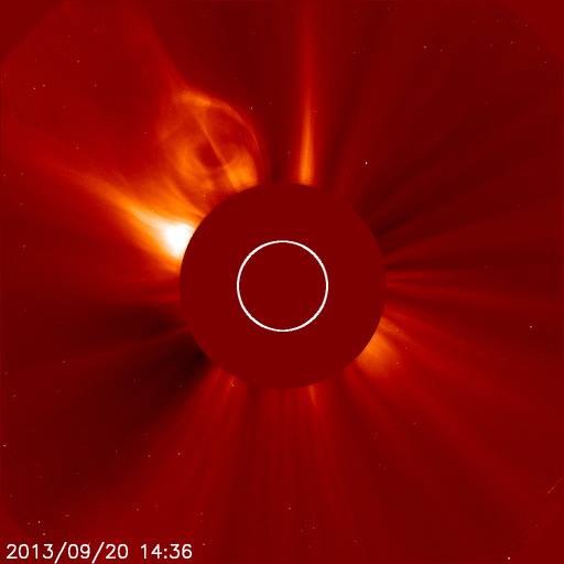
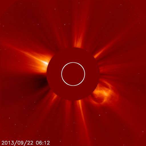
| September
22, 2013 Solar Activity and Time Shift Alert
Update: There are now 4 Earth facing sunspots on the Sun. They are 1845, 1846, 1849, 1850 - as can be seen in this recent SDO image. Click on the image for a larger view. It is 1850 which has been so active the past couple of days, but has been quiet about 24 hours now. The expected solar wind is still en route and is expected possibly as early as tomorrow September 23, 2013 or the next day September 24, 2013. It's still an unknown as to whether any energy from any of the days old multiple CME will hit Earth, and an active prominence on the Sun's southwest limb may lift off the surface. While the prominence probably won't impact Earth energy-wise, as most don't, they can put on a spectacular visual show. According to the continuation of Time Shift marker reports, Time Shift activity is still in progress even though the Earth's magnetic field is no longer unsettled or geomagnetically storming. This is normal behavior for Time Shift activity. Although the onset of geomagnetic activity can trigger Time Shift and time line edit activity, the cessation of geomagnetic activity does not correlate with the stopping of that particularly triggered Time Shift activity. Just so you know. Stay tuned. |
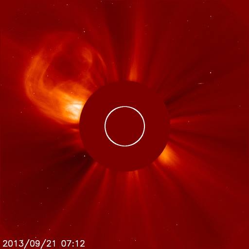
| September
22, 2013 Solar Activity and Time Shift Alert
Update 2: In my earlier report today I wrote, in part: "... an active prominence on the Sun's southwest limb may lift off the surface." Yea me! The prominence has indeed lifted off, in a spectacular looping of solar energy that progressed into becoming a coronal mass ejection [CME]. I am still waiting to see whether any of that energy is Earth directed, although such eruptions sourcing from a solar limb usually do not head toward the Earth. I also wrote, in part on September 21, 2013: "... today's CME has overtaken the torch eruption that I pointed out yesterday. While it may seem that you are looking at a single solar flare, in fact you are looking at a solar flare from sunspot 1850 erupting over the place where the source of the torch flaring has been blasting for more than a day. In fact, once today's CME traveled further away from the Sun and the light bulb shape deconstructed, the torch eruption was again clearly seen. As I said yesterday, this phenomenon is not often seen in tandem - including a torch blast surviving a solar flare/CME with which it becomes entangled." Take a look at this current SOHO photo of the magnetic filament eruption, as well as the September 21, 2013 solar flare eruption entangled with the ongoing torch eruption. Note that while both 'light bulb' shaped eruptions are no longer in form, that torch is still in its ongoing state of eruption. I'm letting you all know that these are some of the interesting solar events to ponder. Not everything amazing on the Sun is related to an X class flare. Some of the greatest discoveries have been made from focusing in on the small details. |
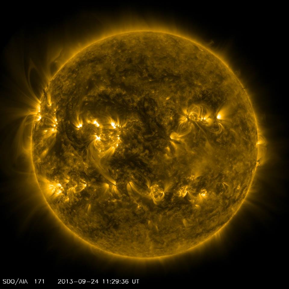
| More
About The Solar Torch Starting with my September 20, 2013 post I showed and reported about a solar event that I called 'the torch'. I called it that because it looks like a blow torch sourcing from the Sun. Even 4 days later, and with multiple solar eruptions all around it, that torch is still burning bright. So I thought you would be interested to take an up close and personal look at what is going on, with the Sun, to create and maintain that torch effect. Take a look at this current SDO photo of the Sun between the 9 and 10 o'clock position. Be sure to click on the photo to see the best view of the photo. What you are looking at are the huge multiple loops of solar plasma that is the source of the torch. Take a look around the entire circumference of the Sun and you won't see another mega looping area like the one that has been sustaining the torch. Now take a look at the 3 o'clock position. That is where there have been multiple C class and B class solar flares erupting as of late. In fact, what you are seeing there now is the end of a B class eruption that happened yesterday September 23, 2013. Stay tuned for more as the wait continues for the expected solar wind and possible CME hits. |
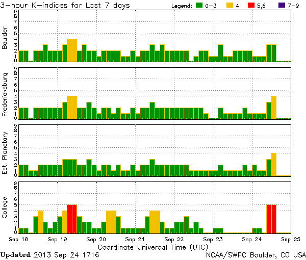
| September
24, 2013 Solar Activity and Time Shift Alert
Update The expected solar wind has arrived and is in progress, as can be seen in this NOAA K-index chart. So far this solar wind has triggered a k-5 [red lines] and k-4 [yellow lines] geomagnetic storm. This particular solar wind announced itself by sending electrical currents into the ground and triggering auroras over northern latitudes. Whether this solar wind is joined by any CME energy is unknown at this time because there is no data beyond the CME having erupted days ago. Click on the chart to see the best view of the chart. This geomagnetic activity has also triggered Time Shift and time line edit activity, which is in progress. |
|
September
24, 2013 Time Shift Alert Update 2:
Time Shift Triggered 7.8 Earthquake In Pakistan Creates New Island In my Time Shift Alert report I wrote, in part: "This geomagnetic activity has also triggered Time Shift and time line edit activity, which is in progress. ... Due to frequency and time line edit changes associated with Time Shifts there may be Time Shift triggered earthquake, volcano, tornado, weather, and geophysical events." Today, September 24, 2013 - as this Time Shift activity progressed - the activity caused a 7.8 magnitude earthquake struck Pakistan. The quake, which has killed 45 people and counting, even caused a new island to form in the Arabian sea. Please remember what I have taught about Time Shifts and earthquakes ... no earthquake is intentionally caused by Time Shift and time line edit activity. The quakes happen randomly as a result of the change in frequency that occurs, as well as the fact that the time line elements are restructured. This makes earthquake fault lines extremely vulnerable during Time Shift activity. While not all earthquakes are triggered by Time Shift activity - some are. In this case, this one is a Time Shift triggered quake. |

| Quake kills 45 in
Pakistan, creates new island in sea By Gul Yusufzai QUETTA, Pakistan (Reuters) - A major earthquake hit a remote part of western Pakistan on Tuesday, killing at least 45 people and prompting a new island to rise from the sea just off the country's southern coast. Tremors were felt as far away as the Indian capital of New Delhi, hundreds of miles (kilometers) to the east, where buildings shook, as well as the sprawling port city of Karachi in Pakistan. The United States Geological Survey said the 7.8 magnitude quake struck 145 miles southeast of Dalbandin in Pakistan's quake-prone province of Baluchistan, which borders Iran. The earthquake was so powerful that it caused the seabed to rise and create a small, mountain-like island about 600 meters (yards) off Pakistan's Gwadar coastline in the Arabian Sea. 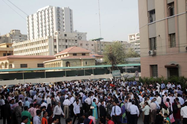 Television channels showed images of a stretch of rocky terrain rising above the sea level, with a crowd of bewildered people gathering on the shore to witness the rare phenomenon. Officials said scores of mud houses were destroyed by aftershocks in the thinly populated mountainous area near the quake epicenter in Baluchistan, a huge barren province of deserts and rugged mountains. Abdul Qadoos, deputy speaker of the Baluchistan assembly, told Reuters that at least 30 percent of houses in the impoverished Awaran district had caved in. The local deputy commissioner in Awaran, Abdul Rasheed Gogazai, and the spokesman of Pakistan's Frontier Corps involved in the rescue effort said at least 45 people had been killed. In the regional capital of Quetta, officials said some areas appeared to be badly damaged but it was hard to assess the impact quickly because the locations were so remote. 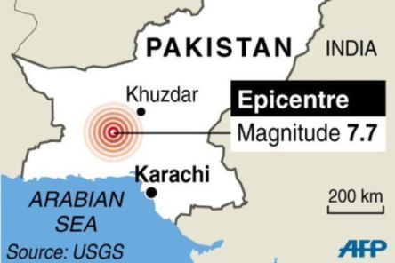 7.7 magnitude earthquake hits
Pakistan, killing dozens
Chief secretary Babar Yaqoob said earlier that 25 people had been injured and that the death toll was expected to increase as many people appeared to be trapped inside their collapsed homes. Local television reported that helicopters carrying relief supplies had been dispatched to the affected area. The army said it had deployed 200 troops to help deal with the disaster. (Writing by Maria Golovnina; Additional reporting by Mehreen Zahra-Malik in Islamabad and David Chance in New Delhi; editing by Mark Heinrich) |
|
September
25, 2013 Time Shift Alert Update 2:
Time Shift Triggered 7.0 Earthquake In Peru Waters In my Time Shift Alert report I wrote, in part: "This geomagnetic activity has also triggered Time Shift and time line edit activity, which is in progress. ... Due to frequency and time line edit changes associated with Time Shifts there may be Time Shift triggered earthquake, volcano, tornado, weather, and geophysical events." Only one day after the September 24, 2013 Time Shift earthquake in Pakistan, the one that created a new island in the Arabian Sea close to shore, another Time Shift triggered earthquake has manifested. This one happened on September 25, 2013 and was a 7.0 magnitude in the waters off of Peru. This appears to be the tail end adjustment to the final time line edit of the latest Time Shift activity. If this isn't the tail end of the latest Time Shift and time line edit activity, then other Time Shift markers will be realized. The area is a known earthquake prone zone, which makes it vulnerable to the time line element restructuring that takes place as part of the Time Shift mechanism. Although the epicenter was in the waters of Peru, the nearest cities were Acari, Peru at 31 miles and the famous lines of Nazca at 76 miles from the epicenter. Please remember what I have taught about Time Shifts and earthquakes ... no earthquake is intentionally caused by Time Shift and time line edit activity. The quakes happen randomly as a result of the change in frequency that occurs, as well as the fact that the time line elements are restructured. This makes earthquake fault lines extremely vulnerable during Time Shift activity. While not all earthquakes are triggered by Time Shift activity - some are. In this case, this one is a Time Shift triggered quake. |
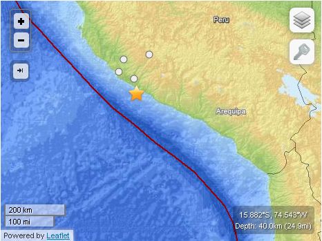
M7.0 - 50km S of
Acari, Peru 2013-09-25 16:42:42 UTCSummaryLocation and Magnitude contributed by: USGS National Earthquake Information CenterEvent Time
Location15.882°S 74.543°W depth=40.0km (24.9mi) Nearby Cities
Tectonic Summary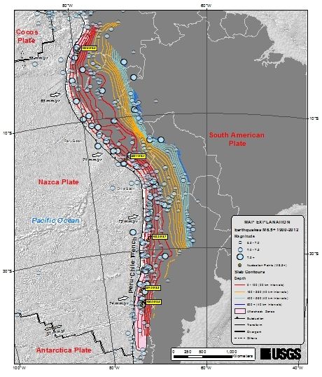
The boundary-region between the Nazca and
South American plates experiences a large number of
earthquakes. The region within 250 km of the
epicenter of the earthquake of September 25 had
experienced seventeen previous earthquakes of magnitude
6 and larger since 1973. The largest of these, the
magnitude 8.4 earthquake of June 23, 2001, occurred
along the plate boundary to the south. It killed
at least 74 people and destroyed over 17,000
homes. The magnitude 7.7 earthquake of November
12, 1996, killed at least 14 people and left 12,000
homeless. It occurred along the plate boundary to
the north of the September 25 epicenter. Seismotectonics of South America (Nazca Plate Region)The South American arc extends over 7,000 km, from the Chilean margin triple junction offshore of southern Chile to its intersection with the Panama fracture zone, offshore of the southern coast of Panama in Central America. It marks the plate boundary between the subducting Nazca plate and the South America plate, where the oceanic crust and lithosphere of the Nazca plate begin their descent into the mantle beneath South America. The convergence associated with this subduction process is responsible for the uplift of the Andes Mountains, and for the active volcanic chain present along much of this deformation front. Relative to a fixed South America plate, the Nazca plate moves slightly north of eastwards at a rate varying from approximately 80 mm/yr in the south to approximately 65 mm/yr in the north. Although the rate of subduction varies little along the entire arc, there are complex changes in the geologic processes along the subduction zone that dramatically influence volcanic activity, crustal deformation, earthquake generation and occurrence all along the western edge of South America. Most of the large earthquakes in South America are constrained to shallow depths of 0 to 70 km resulting from both crustal and interplate deformation. Crustal earthquakes result from deformation and mountain building in the overriding South America plate and generate earthquakes as deep as approximately 50 km. Interplate earthquakes occur due to slip along the dipping interface between the Nazca and the South American plates. Interplate earthquakes in this region are frequent and often large, and occur between the depths of approximately 10 and 60 km. Since 1900, numerous magnitude 8 or larger earthquakes have occurred on this subduction zone interface that were followed by devastating tsunamis, including the 1960 M9.5 earthquake in southern Chile, the largest instrumentally recorded earthquake in the world. Other notable shallow tsunami-generating earthquakes include the 1906 M8.5 earthquake near Esmeraldas, Ecuador, the 1922 M8.5 earthquake near Coquimbo, Chile, the 2001 M8.4 Arequipa, Peru earthquake, the 2007 M8.0 earthquake near Pisco, Peru, and the 2010 M8.8 Maule, Chile earthquake located just north of the 1960 event. Large intermediate-depth earthquakes (those occurring between depths of approximately 70 and 300 km) are relatively limited in size and spatial extent in South America, and occur within the Nazca plate as a result of internal deformation within the subducting plate. These earthquakes generally cluster beneath northern Chile and southwestern Bolivia, and to a lesser extent beneath northern Peru and southern Ecuador, with depths between 110 and 130 km. Most of these earthquakes occur adjacent to the bend in the coastline between Peru and Chile. The most recent large intermediate-depth earthquake in this region was the 2005 M7.8 Tarapaca, Chile earthquake. Earthquakes can also be generated to depths greater than 600 km as a result of continued internal deformation of the subducting Nazca plate. Deep-focus earthquakes in South America are not observed from a depth range of approximately 300 to 500 km. Instead, deep earthquakes in this region occur at depths of 500 to 650 km and are concentrated into two zones: one that runs beneath the Peru-Brazil border and another that extends from central Bolivia to central Argentina. These earthquakes generally do not exhibit large magnitudes. An exception to this was the 1994 Bolivian earthquake in northwestern Bolivia. This M8.2 earthquake occurred at a depth of 631 km, making it the largest deep-focus earthquake instrumentally recorded, and was felt widely throughout South and North America. Subduction of the Nazca plate is geometrically complex and impacts the geology and seismicity of the western edge of South America. The intermediate-depth regions of the subducting Nazca plate can be segmented into five sections based on their angle of subduction beneath the South America plate. Three segments are characterized by steeply dipping subduction; the other two by near-horizontal subduction. The Nazca plate beneath northern Ecuador, southern Peru to northern Chile, and southern Chile descend into the mantle at angles of 25° to 30°. In contrast, the slab beneath southern Ecuador to central Peru, and under central Chile, is subducting at a shallow angle of approximately 10° or less. In these regions of “flat-slab” subduction, the Nazca plate moves horizontally for several hundred kilometers before continuing its descent into the mantle, and is shadowed by an extended zone of crustal seismicity in the overlying South America plate. Although the South America plate exhibits a chain of active volcanism resulting from the subduction and partial melting of the Nazca oceanic lithosphere along most of the arc, these regions of inferred shallow subduction correlate with an absence of volcanic activity. |
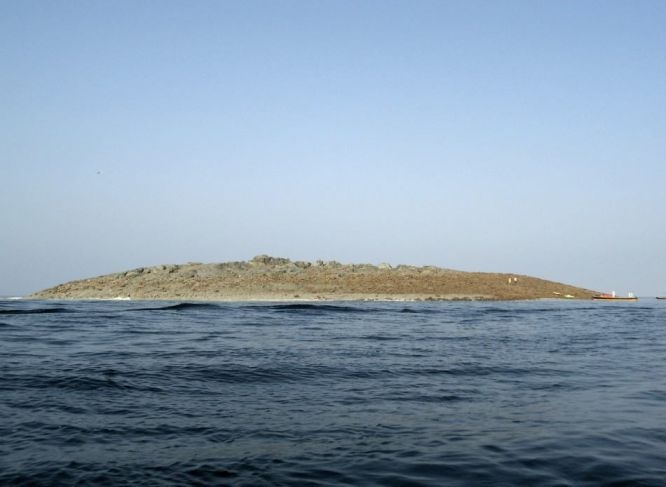
| Time
Shift Time Line Edits and Terra-Forming On September 24, 2013, in a Time Shift Alert update, I reported about a Time Shift triggered 7.8 earthquake in Pakistan that created a new island. There is a short list of natural reasons why an island would suddenly rise up from out of the sea. Volcanic activity is at the top of the list, followed by earthquake related activity which can include anything from the seabed being pushed up to a slew of mud and rocks being displaced in a heap that peaks out above the water surface. But there is another type of event that can create islands in the sea, and that event is Time Shift time line editing that leads to terra-forming. Terra-forming is the process of altering a planet's surface for some specific reason. Terra-forming can be a natural event, a man-made mechanical event, or a time line edit event that may encompass both natural and mechanical sources. I have uploaded a photo of the island in question, taken by Reuters on September 24, 2013 when the island was reported to have risen. Witnesses reported that the island appeared as the 7.8 Pakistan earthquake was underway, and yet no witness can say how the island formed. No witness actually saw the island rise or form. It wasn't there and then it was there. Of course it's quite possible that the powerful earthquake event itself caused witnesses to be engaged in earthquake survival activities, so that their attention was not on an empty spot of water off shore. But there are other physical clues which tell a more amazing story about the origin of this new Pakistan island. When researching Time Shift markers, which are those odd events which do not seem to fit in to the time line such as the Time Shift Living Dead enigma. Then there is that new island. Regardless of how that island got there ... it is now there ... and from a purely scientific point of view there are things about it that make no sense - unless you know about time line editing. The are many physical clues that something is seriously odd about that mew island appearing, and these clues are besides the fact that the island appeared while a known Time Shift event is in progress. These other clues send up red flags that something isn't physically right. The first is the fact that the island appeared many, many miles from the epicenter of the quake - which was on land. It's one thing if the epicenter of a quake pushes up the seabed, which then creates an island. But when the epicenter isn't even near the new island that in itself is an oddity - regardless of whether the island was formed by the seabed rising or what is called a mud volcano. A mud volcano is different from a lava volcano. you see, regardless of the mechanism, a whole lot of sea water rapidly was displaced when the island formed. Physical science teaches that such a sea water displacement must cause the displaced water to go somewhere. This is tsunami science. This island formed only 350 off shore, and was about 100 yards long and 40 feet high. Yet the shore line and inland did not flood. All of that water was displaced and nothing flooded, nor was there a tsunami warning. Where did the displaced water go? If this island appeared as part of a geophysical caused time line edit, then of course it would appear from out of nowhere without all of the physical elements surrounding the island creation process. This appears to be what has happened, and such a Time Shift time line edit event is not unique in this and other parts of the world. The planet changes every time there are Time Shifts. Some of tiny changes and some are so huge that whole land masses are involved. Anytime that any of these time line edits is retained in our consciousness - aka the newest co-existing time line - that in itself is a fantastic thing to behold. It's the tip of the iceberg of time line changes. Most of the physical changes observed have nothing to do with earthquakes. This new island was not caused by an earthquake. It only appeared in conjunction with a Time Shift related quake. The island's sudden appearance is the residual of what I refer to as a sloppy time line edit. Without those sloppy time line edits i would never have discovered Time Shifts. The island was suddenly just there, where before 'there' was just water. Now you don't see it, now you do. That is typical. Co-existing time lines do not join. The editing of a time line creates a new and separate time line called a co-existing time line. |
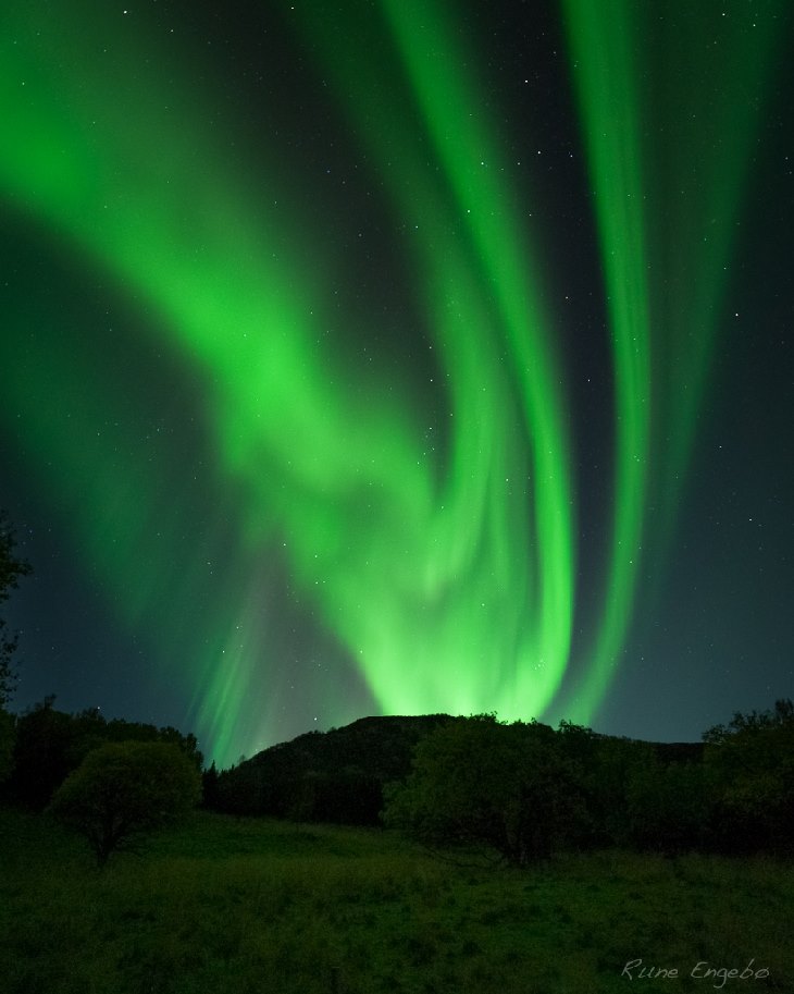
| September
24, 2013 Vortex Shaped Swirling Aurora Over Norway This amazing looking green vortex shaped swirling aurora appeared over Tromso, Norway by Rune Engebo, on September 24, 2013 during the geomagnetic storming that I reported about. This is the same geomagnetic condition that triggered Time Shift and time line activity, on that date, as well as triggering two large earthquakes: a 7.8 magnitude quake in Pakistan, and the 7.0 magnitude quakes in Peru. The Time Shift quake, in Pakistan, was the time line edit event that manifested the new island not far from shore in the Arabian Sea. Even though auroras do not trigger Time Shifts, nor do Time Shifts trigger auroras, the appearance of auroras sometimes act as a Time Shift marker alerting that a Time Shift is in progress. This is because the same energy, that can trigger an aurora, is the same energy that can sometimes trigger Time Shift and time line edit activity. |
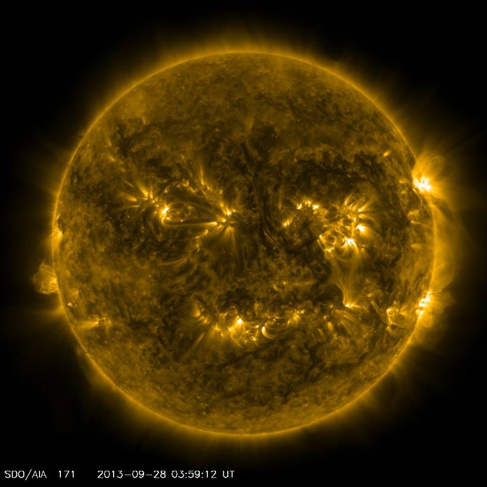
| September
29, 2013 Solar Activity Update: Smiley Face On The Sun I was going through photos of the Sun, as I always do, and this SDO solar photo from September 28, 2013 got me laughing because there appears to be a big "smiley face' on the Sun. Have a look and see what you see. Make sure that you click on the photo to see the whole photo for the best view. BTW, there have been a few C class solar flares the past 2 days, but so far nothing that is Earth directed. Right now the Sun is down to 3 Earth facing sunspots, with none of them being exactly centered toward Earth. I expect things to pick up as we move into October. |
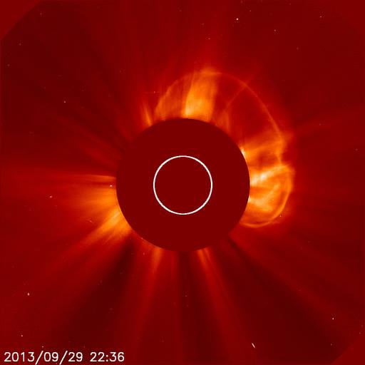
| September
30, 2013 Solar Activity and Time Shift Alert: Solar magnetic filament erupts September 29, 2013 and develops a massive and powerful CME with an S2 radiation storm impacting Earth now On September 29, 2013 I noticed that a magnetic filament, on the Sun, had erupted and released a huge and dramatic coronal mass ejection [CME]. But in one of those frustrating things that happen with scientific data associated with such powerful events, it took NASA hours to properly prepare and release the photos associated with this stellar event. Even though I was able to track the progress of this huge near halo event, I did not have the images to share until now. This event has currently been classified as a C class solar flare event, which is not correct. There may be a C class solar flare in there somewhere, but the entire event acts and looks more like an M class event. I expect a reclassification correction. As you can see, in this SOHO image from yesterday September 29, 2013, this is no ordinary CME. This CME continued into today September 30, 2013. The magnetic filament, which had been growing for days on the Earth facing side of the Sun, was quite long and large when it erupted. Its CME rims the Sun's circumference from the 11 o'clock position to the 4 o'clock position. I have rarely seen anything like that. A sunspot's CME, due to the sunspot's localized size, generally only erupts with a fraction of the width that you see with this magnetic filament CME. While this particular photo is amazing in itself, what came next is even more amazing - and you have to see it for yourself. This is why I am adding more photos to this report, in the reply section of this report. So be sure to look at them too. And be sure that you click on all photos so that you see the entire photo. Otherwise you won't be able to see the best possible view. This CME also triggered a solar proton storm that is currently impacting Earth as an S2 solar radiation storm. It started as an S1 storm and grew. An S2 solar radiation storm is a moderate storm that can be a radiation hazard for astronauts in orbit as well as passengers in high latitude planes. Some satellites may have single event dropouts, and navigation in the Earth polar regions can be disrupted. The rest of the energy, from this massive CME, has already sped away from the Sun with parts of it heading for Earth. Such an Earth impact would trigger geomagnetic storming, which in turn will trigger Time Shift and time line edit activity. |
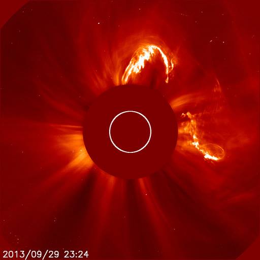
| This is how the above September 29, 2013 massive CME, from a solar magnetic filament, transformed into an even more powerful CME. |
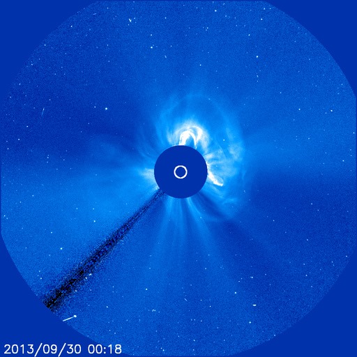
| Here is the same CME on a different SOHO camera, which allows for a wider angle of the CME event. |
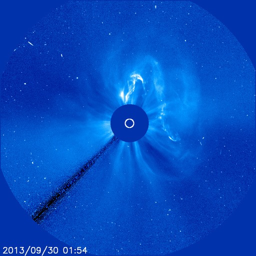
| Here again is the same CME, except that now it is spreading out - in layers - into space at a terrific speed. |
| In this closer angle SOHO photo, the bulk of the CME has traveled away from the Sun. In its place is a moderate proton storm, which can be seen in those white specs in the photo. |
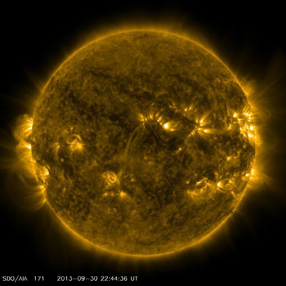
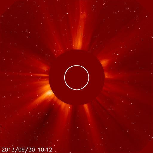
| September
30, 2013 Solar Activity and Time Shift Alert
Update: CME expected to reach Earth between October 2-3, 2013 As I hoped would happen, and as I wrote in today's earlier report, this event was not a single eruption event and was not merely a C class eruption. This was, as I deduced, a combination eruption of the C class solar flare and the more powerful magnetic filament eruption. The correction has now been formerly made and reads, in part from NOAA: "2013-09-30 20:50 UTC G1 Geomagnetic Storm Expected: A filament eruption and associated low-level solar flare (below the R1, Minor level) occurred late Sunday afternoon, Sep 29th, (start of day Sep 30th UTC) producing a S2 (Moderate) solar radiation storm which remains in progress at this time. The filament eruption resulted in a partially Earth-directed coronal mass ejection (CME). As a result, G1 geomagnetic storming is expected mid-day on October 2nd through the 3rd." Actually, NOAA's released statement had a typo-glitch that read "G1 geomagnetic storming is expected mid-day on September 2nd through the 3rd." I corrected the wrong month of September and swapped in October for accuracy. Maybe this was nothing more than a typo, and maybe it was a Time Shift glitch. I can't say. I'm just reporting it for the record. Here is the latest September 30, 2013 photo of the Sun from SDO. SOHO has not released any further photos, so the photos that I shared in the earlier report remains the latest photos available from them in that format. If needed, I'll use images from a different camera. They are not as clear, but at least it will be something tangible for educational purposes. Note all of the plasma and magnetic filament looping. This indicates that the solar energy, which created the recent massive CME and the smaller C class solar flares, is still very active on and above the surface of the Sun. |
![]()
![]()
| |
| |
| |
| |
| |
All contents copyright ©2012 by Starfire Tor